
Protected natural areas
Protected natural areas
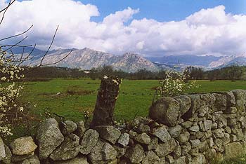
This region has several legal frameworks that guarantee the conservation of its natural values. These natural spaces are home to species such as the black vulture, the ibex, the Iberian imperial eagle or the Elizabethan butterfly, among others.


Sierra de Guadarrama National Park
It is located in the eastern part of the Central System and extends along the summits of the Sierra de Guadarrama, encompasses 33,960 hectares, of which almost 64% belongs to Madrid Autonomous Community and just over 36% to Segovia, in Castilla and León Autonomous Community. The Peñalara Peak, with its 2,428 meters above the sea level, is the highest peak, and together with four other surrounding peaks, of more than 2,271 m, form the ridge of the scenic Peñalara Massif, which spreads out from Los Cotos Pass, in the N-NE direction, to the peak of Los Neveros. From this point, the National Park continues towards the northeast, following the Sierra de Guadarrama central axis, passing through the Navafría Pass, up to Reajo Alto Peak (2,100 m). There is another impressive mountain ridge, Cuerda Larga, which starts at Navacerrada Pass; for 16 km, its height remains of over 2,000 m, reaching the maximum height of 2,383 m at Cabezas de Hierro. The Puerto de la Morcuera marks the end of the Cuerda Larga ridge and the beginning of the Sierra de la Morcuera. This mountain chain, less high than the precedent, spreads out further the National Park limits. Other mountains and peaks of interest are Siete Picos, which lies between the Navacerrada Pass and the La Fuenfría Pass, Sierra de los Porrones, La Pedriza, Peña del Oso (2,196 m) and Montón de Trigo (2,195 m). The National Park encompasses 33,960 hectares of the Sierra de Guadarrama in the Central System, a mountainous massif that halves the Castilian plateau and separates the Duero and the Tajo River basins and also Madrid and Segovia Provinces. Most of its surface is formed by peaks on which rocky outcrops, mountain pastures and shrubs prevail. During the Park pronouncement process, at a certain time it was named “Sierra de Guadarrama Heights National Park”, but the inclusion of extensive areas of pine forest, and other not so large of Pyrenean oak covering the Supramediterranean and Oromediterranean bioclimatic floors made the word “heights” meaningless.
Upper Manzanares River Basin Regional Park
The Upper Manzanares River Basin Regional Park is located in the central area of the Iberian Peninsula, in the territory of Madrid Autonomous Community, northwest of the city of Madrid.
The Upper Manzanares River Basin Regional Park is the oldest protected area and, perhaps, the most representative of the Madrid region. Proof of this is that already in 1930, Pedriza del Manzanares was declared a “Natural Site of National Interest”, for its unique beauty. Later in 1978, given that the boost in mountain tourism increasingly affected sites of high ecological value, it had to be reclassified as a Natural Park, extending the limits set out above.
Soon enough arose the idea of connecting this emblematic place of the Madrid Sierra with another natural treasure, the oak spot that forms the El Pardo Mount, a few kilometres from the capital city. What links these two natural jewels of Madrid region is the Manzanares River and the surrounding places that underwent (and still do) a lighter transformation compared to other areas of the Sierra, maintaining traditional uses and remarkable conservation levels.
This idea was embodied with the enactment of Law 1/1985, of the 23rd of January, of the Upper Manzanares River Basin Regional Park with an area of 37500 ha. The subsequent extensions (years 1987, 1991, 1993 and 2003) set an area of around 52800 ha. In 2013, with the declaration of the Sierra de Guadarrama National Park, this area covered 42583 ha, given that part of the land incorporated therein was declassified as a territorial area of the Upper Manzanares River Basin Regional Park.
This Law (1/1985) tries to find a balance between the active conservation of ecosystems and the strengthening of traditional productive activities, without forgetting the importance of the recreational use that historically this Madrid enclave has had, given its proximity to a large city.
The harmony achieved between the development of local villages and town and the conservation of the natural environment led to the inclusion of the Upper Manzanares River Basin Regional Park into the International Network of Biosphere Reserves, in 1992.


Biosphere Reserve of the Upper Manzanares River Basin
The biosphere reserves are representative areas of the different habitats of the planet, whose importance for the conservation of biodiversity and as a model of sustainable development is internationally recognised by UNESCO (United Nations Educational, Scientific and Culture).
In terms of physiographic units, it includes two elevations: The Cuerda Larga and the Sierra de Hoyo, and among them, the Manzanares depression and the Colmenar Viejo slope, to reach the Madrid arkose meadow in the south. Its dominant lithology is granitic, influenced by atmospheric agents, standing out the unique enclave of La Pedriza.
The Manzanares River flows across these lands as a joining axis. In all this physiographic and climatic variety there are different environmental units such as high mountain ecosystems, coniferous forests, sclerophilic deciduous and riverbank forests, Pyrenean oak forests, ash tree forests, as well as pastures and grasslands. Numerous species among which some raptors stand out (Iberian imperial eagle, griffon vulture, peregrine falcon and golden eagle among others), small birds, amphibians and reptiles live in these habitats. The Santillana Reservoir is noteworthy for its richness in aquatic fauna, with a great abundance of ducks, geese, and swans, some of them protected.
Other protected natural areas
The conservation of the different types of habitat and species entails the obligation to designate spaces of the Natura 2000 Network. In the territory there are three Places of Community Interest (SCI) of the Natura 2000 Network; SCI of the Guadarrama River Basin, SCI of the Manzanares River Basin and SCI of the Lozoya River and Sierra Norte. Besides, our region has reservoirs and wetlands such as the La Jarosa Reservoir in Guadarrama, the Navacerrada Reservoir and the Santillana Reservoir in Manzanares El Real and with the Peñas del Arcipreste de Hita Natural Monument.

